|
Municipal Planning
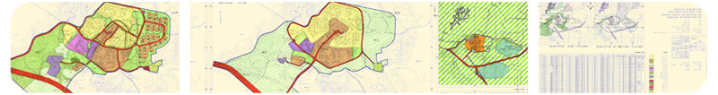
You can now view and monitor important city planning data. Information related to zoning districts, their locations and boundaries, land use and development can be easily managed using a simple integrated system.
Your essential tool for planningMunicipal planning often means orchestrating enormous amount of data (commercial, residential and manufacturing disricts; low, medium and high density etc.).It often requires coordination between different professionals and different sources of data. Along the way, a great amount of crucial data gets accumulated in various digital and printed files.Due to the intense, collaborative nature and the vast amount of scattered data, it often becomes impossible to navigate through the maps and plans.
Marom introduced a system that aggregates the entire planning database. Using a structured process with a proven track record, Marom's system has transformed Infrastructure Management for hundreds of organizations in various sectors and sizes. Your tool for a macro and micro perspectiveHow easily can you determine a specific neighborhood's commercial overlay? Or observe the limited height districts and analyze the data with respect to the new proposed plans? Can you easily determine the required area of open space, the distance between the buildings, or the amount of permitted parking area?Especially in those cases, when there is a lot of precise, crucial information at hand, time and resources are often being wasted in an attempt to aggregate old and new data and communicate with the key professionals. At that point, Marom's expertise comes into play:Marom aggregates and compiles old and new data, maps and plans and provides you with a broad perspective. Three easy steps:
- Turn on the system.
- Choose the relevant area.
- View and analyze all of the relevant maps and data- presented in colorful layers over an aerial photo, using adjustable resolutions.
What are the benefits of using Marom's system?• Effective communication: a consistent set of data is being used by all parties involved• Clear, interactive display of all the relevant plans and maps• Broad perspective of the facility and infrastructure makes decision-making easy and efficient• Important data is always accessible- no need to rely on a specific person's knowledge• Quick integration between existing infrastructure maps and new plans• Easy access to high resolution original plans• 100% customizable to the specific organization's need
contact us today to learn how you can control your maps and plans, and have your data work for you!
|
|